European Rapid Earthquake Loss Assessment
What is rapid earthquake loss assessment?
When an earthquake occurs, there are many remote sensors that record data from the event: waveforms recorded by seismic instruments are used to locate the hypocentre and magnitude of the earthquake and to assess the strong ground shaking at the surface of the earth; people and buildings feel the shaking and observe or record the impact that it has on them. All of these data can be used to rapidly estimate, in the minutes, hours or days following an earthquake, the impact that the earthquake has on the surrounding people, buildings and infrastructure. In the first few minutes following an earthquake, a simple qualitative assessment (e.g., no impact, minor impact, major impact) is often sufficient to understand the magnitude of the event, and this is referred to as Rapid Impact Assessment In the following hours, however, it becomes important to understand the impact in terms of quantitative losses (e.g., number of collapsed buildings, number of fatalities or homeless people, direct economic loss) and this estimation is referred to as Rapid Loss Assessment. This fast assessment of the impact of the earthquake provides first-order estimates of the losses which can be continually updated as more information and data arrive from the remote sensors.
Why do we need to rapidly assess losses after earthquakes?
It can often take days or even months for the true toll of an earthquake to be measured and reported. Stakeholders such as early responders, governments, and the insurance industry all need to have an estimate of the potential magnitude of the losses much earlier than this, so that they can plan and better manage the recovery phase after the earthquake. For example:
- Early responders such as civil protection agencies need to know which areas have been most hit, and the scale of collapsed buildings, so that they can send the right teams and equipment to search for trapped survivors. They will also need an estimate of the number of homeless people, so they can prepare emergency shelter.
- Governments may need to allocate funding for the rescue and recovery efforts, either nationally or as part of international aid, when the event has occurred in another country.
Insurers need to plan for post-earthquake damage assessments to manage the potential insurance claims (e.g., [1]). Whilst these initial rapid estimates of loss are statistical (i.e., they can only provide a distribution of the expected damage and loss, rather than identify specific buildings that will be damaged) and they contain a number of uncertainties, they nevertheless provide useful, actionable information for these communities.
Citation
Crowley, Helen, Michelini, Alberto, Cauzzi, Carlo, & Bossu, Rémy. (2022). Good practice report: european rapid earthquake loss assessment. Zenodo. https://doi.org/10.5281/zenodo.8075095
Reviewers
Iunio Iervolino, Eugenio Chioccarelli, Pasquale Cito
How are European earthquake losses rapidly assessed in the RISE project?
For over 13 years, the U.S. Geological Survey (USGS) has been running a global rapid loss assessment service called PAGER (Prompt Assessment of Global Earthquakes for Response [1]), that makes use of ShakeMap [3]. ShakeMap provides an estimate of ground shaking in the area struck by an earthquake. An earthquake with a specific magnitude, location and depth will produce a range of ground shaking levels at sites throughout the region depending on distance from the earthquake, the local site conditions, and variations in the propagation of seismic waves from the earthquake, due to complexities in the structure of the Earth's crust. Ground shaking levels can be represented through macroseismic intensity, which is a description of the effect of the earthquake on people and structures (e.g., [4]), or through measured shaking parameters, such as the peak acceleration of the ground recorded by an accelerograph. Following an earthquake, data on the ground shaking from both observations of macroseismic intensity and recordings from seismic instruments are automatically processed and distributed via dedicated software and web services, without the need for any human intervention. These data are combined with empirical ground motion models (applied to the areas without any data), to produce maps of likely ground shaking. The accuracy of the resulting ShakeMap will depends on the density of the observations and on the faithful-ness of the ground motions model(s) to represent the ground motion where no observations are present.
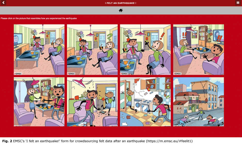
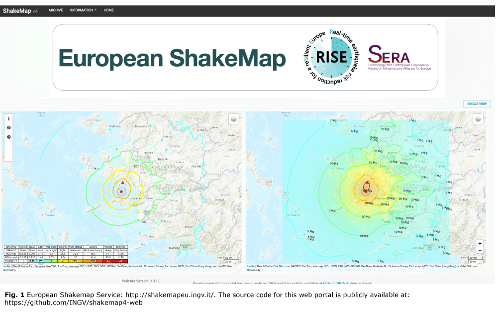
Within RISE, a European ShakeMap service prototype using the latest version of ShakeMap (v4, [5]) has been set up under the management and mainte-nance of both ETH Zurich and the National Institute for Geophysics and Volcanology in Italy (INGV) (Fig 1). A number of web services produced by EMSC (the European-Mediterranean Seismological Centre) and ORFEUS (Observatories and Research Facilities for European Seismology) are used by the European ShakeMap system to automatically register when an earthquake above magnitude 4 occurs within Europe, and to receive any recorded strong motion data. The European ShakeMap system is fully consistent with the data and modelling protocols used in the na-tional services for Italy and Switzerland (and also therefore could serve as a backup for these national installations), and there are plans to expand this harmonisation to other European countries. Future developments will include the inclusion of crowdsourced felt data, being collected by web services developed by EMSC, as this can be correlated with macro-seismic intensity (Fig 2).

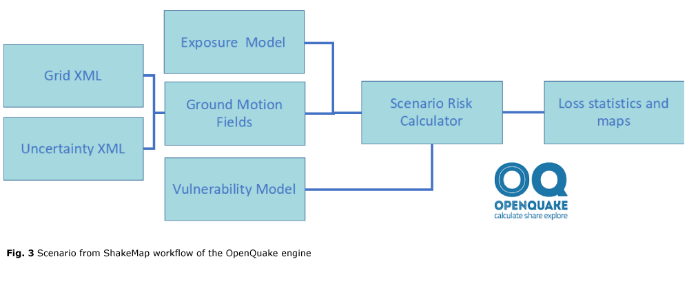
The USGS’s PAGER system uses global exposure and vulnerability models to assess the losses from earthquakes (e.g., [6], [7], [8]). An exposure model provides information about the spatial distribution of residential and non-residential building classes in terms of building count, area, occupants and replacement cost. Vulnerability models provide an estimation of damage to buildings and their contents under given levels of ground shaking, and the ensu-ing economic losses and loss of life. In Europe, we make use of European exposure and vulnerability models that were initiated in the Horizon 2020 SERA project and have been completed in the RISE project, and made publicly available through the risk services of EFEHR (European Facilities for Earthquake Hazard and Risk) [9]. These models have been formatted as input files for the Open-Quake-engine, an open source software for seismic hazard and risk assessment (https://github.com/gem/oq-engine), and can be used in the workflow shown in Fig 3 to produce damage and loss statistics and maps, once the appropriate ShakeMap data (i.e., grid and uncertainty xml files) have been downloaded from the European ShakeMap service.

A first version demonstrator of the European Rapid Earthquake Loss Assessment service has been openly published on a GitLab repository. This demonstrator uses web services to automatically download ShakeMaps as soon as they have been published on the European ShakeMap system, retrieves the exposure models for the countries covered by the Shake-Map grid, and launches the scenario damage and risk calculations with the OpenQuake-engine. Future developments to this demonstrator will include the disaggregation of the exposure data to a high-resolution grid, using openly available tools partially developed in RISE [10], connection to the Global Dynamic Exposure Model, and the automatic generation of a summary PDF file summarising the main statistics and maps obtained from the analyses. This demonstrator is thus the first step towards operationalising state-of-the-art rapid earthquake loss assessment in Europe.
